Map
More from South Dakota

Black Elk Peak Trail in Fog, Black Hills, South Dakota
The trail to Black Elk Peak, formerly Harney Peak, ascends through a misty forest in South Dakota's Black Hills. This…

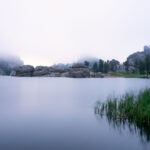
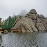
Cathedral Spires, Black Hills, South Dakota, Morning Fog
Low clouds and fog envelop the granite spires of the Cathedral Spires in South Dakota's Black Hills shortly after dawn.…

Abandoned Gold Rush Mine Entrance, Black Hills, SD
This abandoned mine entrance in the Black Hills of South Dakota is a relic of the region's 19th-century gold rush.…

Black Elk Peak Trail in Fog, South Dakota
The trail to Black Elk Peak in South Dakota's Black Hills is shrouded in fog, with light rain making the…

Black Elk Peak Trail in Fog, Black Hills, South Dakota
A trail ascends through a ponderosa pine forest on Black Elk Peak in South Dakota's Black Hills, shrouded in morning…

Abandoned Mine Entrance, Black Hills, South Dakota
This natural rock formation, resembling an abandoned mine entrance, is located in the Black Hills region of South Dakota. The…
Nearby Photos


