Map
More from London

London Underground trains at Piccadilly Circus Station
Piccadilly Circus Station on the London Underground has two trains on the curved deep-level platform. The station sits beneath Piccadilly…

Baker Street Station Metropolitan Line Platform, London
Baker Street Station’s Metropolitan Line platform in London is one of the oldest surviving sections of the Underground. The platform…

Charing Cross Underground Station Bakerloo Line Terminus, London
Charing Cross Underground Station in central London is the southern terminus of the Bakerloo line. A Bakerloo train stands at…

Buckingham Palace Guard at Archway, London
A King's Guard stands sentry at Buckingham Palace in London. The ceremonial post is positioned beside one of the palace…

Piccadilly Circus Station Passageway, London
Piccadilly Circus Station in London has a tiled underground passageway leading to a stairway between platforms and ticket areas. The…

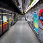
Westminster Station Escalator Hall, London
Westminster Station in London features the Jubilee line extension concourse and escalator hall. The station was rebuilt in the 1990s…
Nearby Photos


