Map
More from Antigua

Agua Volcano Overlooking Antigua Guatemala Street
The Agua Volcano looms over a street in Antigua, Guatemala, a city renowned for its well-preserved Spanish colonial architecture. Founded…

Hotel Room at Casa Bella Boutique, Antigua Guatemala
This hotel room is located at Casa Bella Boutique in Antigua Guatemala. The room features textured yellow walls, a stone…

Fuego Volcano Eruption, Guatemala
The Fuego Volcano, located near Antigua, Guatemala, is one of Central America's most active volcanoes. It is part of the…

Antigua Guatemala Cathedral Facade with Pigeons
The facade of the Antigua Guatemala Cathedral, officially known as the Cathedral of Saint James the Apostle, stands against a…

Santuario San Francisco el Grande Ruins, Antigua, Guatemala
The ruins of Santuario San Francisco el Grande in Antigua, Guatemala, stand as a testament to the city's colonial past.…

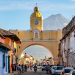
Santa Catalina Arch and Cobblestone Street, Antigua, Guatemala
The Santa Catalina Arch, a prominent landmark in Antigua, Guatemala, was constructed in the 17th century. Originally part of a…
Nearby Photos


